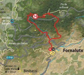
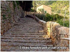
The proposed route is between the town of Fornalutx and its historic Comuna de Sa Bassa. It involves a steep ascent between the town and the common land via the S’Alcina Fumadorapathwhichcontinues with a short trip through the interior of Sa Comuna to immediately descend to the town via its old path, also called Bosquet de Sa Comuna. Plaza de Espanya in Fornalutx is our point of departure. We take the steps on the Calle de la Iglesia which further up becomes Calle Tramuntana and we head on between notable buildings such as Can Xandre, Can Maiol and, already on the way out of the town, Ca Ses Escolanes, with Interesting details of painted tiles. Calle de Tramuntana, known as calle del Monte, gives way to a very elaborate cobbled path. Between terraces of olive groves and orange trees we head on, getting a better view of Penya des Migdia or the Marroig sarea. We cross the road and follow the indications of wooden signs. A small stretch fit for vehicles again gives away to the firm cobbled path (on the left), always flanked by olive groves. At our feet the town of Fornalutx becomes visible; slightly further away you can make out Coll de Sóller and the Alfábia mountain range.
|
We continue the long ascent along a path set between two walls which separate us from the olive groves and where the pines begin to become more common. In this way we arrive at the Puig Major road (km 42,950) and on the right we go on for around a hundred paces until locating a wooden pass for day-trippers in the shade of two gigantic pines. Now the path now goes between oak woods and begins to lose definition until reaching an old threshing floor for the coal silo, from where a cart track gently ascends which has to follow between pine trees, holm oaks and wild olives and already within Sa Comuna. We leave behind a tank intended for the fight against forest fires and we reach a crossroads. We must ignore the path which would take us to the plain of Sa Bassa on the right and follow it via that on the left, going round a small vaulted well. Next we come across a kind of pass with some amazing views over the Sóller valley. From here a long descent is started via a dense oak wood rife with bends and which, after crossing a metallic wrought iron gate, leaves on the Puig Major road. We descend it for around 150 metres until reaching a green wall on the left which we must flank round on the right. We leave the asphalted path to follow an old one, cobbled on certain stretches, and now following a steep river bed. This path leaves us again on the asphalted path which we follow until locating a small olive grove shed from where we go straight on to the bank of the stream. After passing a fence the broad path ends and we cross the stream which descends, always to the right, reaching the area known as Ses Fonts; here we again leave the asphalted path to follow the course of the stream on the left. Next we retake the road which goes down to Fornalutx, meeting the S’Alcina Fumadora pathon which we started this route. |
 |
||||||||||||||||||||
 Download
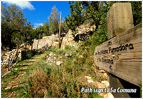
See Description of the Route |
||||||
 |
||||||
|
||||
|
||||