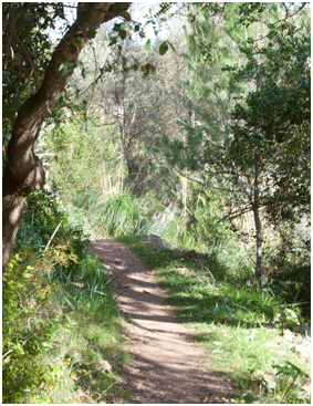
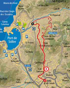
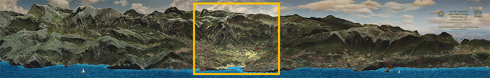
Leave the main entrance to the hotel, keep going right until reaching camí de sa figuera, a street we follow on the left. After leaving behind the Huerta church we go straight on along the same path until reaching the road Soller lluc. We cross the road and resume the route via can tamany road. After paying a visit to the village of the same name, we start to go up Coll de Borrassar. Around 15 minutes later we reach the summit. Ignoring the road that diverts to the right we now go down as far as Port de Sóller. After around 200 paces we are left with two options and we must continue along the path that diverts to the left. But first of all, we go straight on for around 200 paces to pay a visit to the houses of the area. We then resume the path where we left it and after half an hour’s walking we reach Port de Sóller. From the main entrance to the estate, the walk kicks off on camino de la Villalonga which in a few paces leaves us at camí de sa Figuera, a Street which will guide us to the starting point of the route, offering us a pleasant promenade running between the country houses and the growing areas of Huerta de Sóller where the harvesting of citruses and vegetables prevails. With the constant presence of the citrus orchards that are bedeck the valley, we are also drawn to the biodiversity and richness of its trees and plants. Orange trees, lemon trees, banana trees, palm trees and avocados grow lushly thanks to the microclimate characteristic of the valley. After a crossroads, we then leave behind the garden church or iglesia de “la Mare de Deu de la Victoria“ which was built between 1917 and 1923; commemorating the victory of the “sollerics” after an attack by pirates. As our route moves away from Sóller, the citrus orchards begin to take pride of place in the landscape. Finally, the camí de Sa Figuera says farewell with a smooth downward slope whilst in the distance, if we look towards the west, we can see a beautiful view over Sierra de Tramuntana. Once situated beside the busy road that connects Sóller and Lluc, the starting point of the route, the trajectory commences on the other side of the road at Can Tamany, endowed with an asphalted track that runs between another small core of country houses after crossing a small water course; the path surprises us with houses of the same name. The houses of Can Tamany, in actual fact, form part of a group of other buildings which are arranged in linear fashion in a southerly direction, being set back by the mountains of Sa Mola. Situated right under Puig Roig, from the houses our attention is drawn by a reddish rock, popularly known as Sa Roca Rotja on whose summit there is a well-known archaeological site. Under the village wattle we can see some details. For example, our attention is drawn by some samples of painted tiles or a commemorative plaque bearing text in Majorcan: ”To the courageous
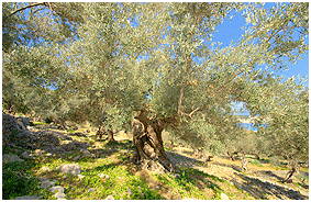
|
women of Can Tamany, the heroines of May 11th 1561" referring to one of the historic events most frequently recalled in the village in which two sisters faced up to a squad of Turks who were looting one of the houses. After the visit, we resume our path which now diverts to the left via a cart path which, endowed with highly worn cobbles, goes straight up to the houses of Can Terés. Right before reaching said property the route is diverted via a short, cobbled side path which, in the form of a rising track, crosses lush vegetation, providing us with a beautiful view over Sierra de Tramuntana, where Els Cornadors takes pride of place. The path immediately gives way to another narrower, barely marked path which, amongst almond trees and terraces, runs between the final houses of the residents, until we reach the height of the houses of Can Penya. With small stone steps, another little path springs up which flanks the orange tree estate, running between the lush vegetation of shrubs and which finally leaves us at another crossroads. It does not matter whether you go up the short cut opposite, which consists of a side horse trail, or via the cart path that ascends on the left as both converge further up, going into a forest packed with pines, holm oaks and olive trees. From this point onwards, the gentle ascent starts to Coll d’en Borrassar which runs in the shade of a pine grove. Gradually, as we approach the summit, the Sóller valley bids us farewell with a beautiful look back at some of the majestic peaks that surround the valley until a forking of paths appears, telling us that we have already reached the highest point of the route. Situated at the summit of Coll d’en Borrassar, right at the height of the Can Gall property with the sound of the cowbells of that cattle that passes near the path, our route starts the descent down to the Port de Sóller, via the path Son Llampayes, which advances between a flat stretch of olive trees and terraces on the left and vegetation comprising pine trees and native plants on the right; in the distance we can already make out the silhouette of “Torre picada”, the largest defence tower in Majorca. Discreetly, it lies above the sea and tells us that the Port de Sóller is not very far away now. We are then drawn by a path that diverts to the left in the shade of a wild olive tree, with some beautiful steps that afford an excellent finish. We will join it later but first it is worth going down a few more metres via the path of Son Llampàyes and paying a visit to the houses of the same name. After a gate our route now runs on a reddish earth path, surrounded by a landscape in which the different tones going to make up the Mediterranean green are in perfect harmony. Located between El Coll d’en Marquès and the mountains of Sa Mola, we then come across the houses of Son Llampayes. In actual fact, this building consists of a set of houses formed by a single vessel and two independent dwellings. One of the houses is Can Alfonso where it is worth paying a visit and enjoying a refreshing orange juice. After enjoying the charm of this spot with a refreshing orange juice, we resume the path where we had left it and with some beautiful steps made with rounded edges, we start the descent on a path that runs surrounded by lush vegetation until reaching what seems to be the start of a water course. After leaving a ditch on our left, the path now becomes stony and in an advanced state of degradation and with a gentle gradient it leaves us in a pine forest from where we descend further on a barely marked path. As we come to the end of our route, we will see that the forest starts losing height until we reach another shrubby area. Now located near the road that joins Port de Sóller with its village, the route runs between a lime kiln and a stone hut. After two barriers we reach the end of the route. |
|
|||||||||||||||

See Description of the Route |
|||||||
 |
|||||||
|
||||
|
||||