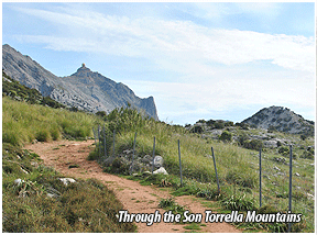
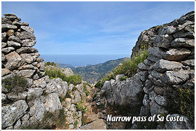
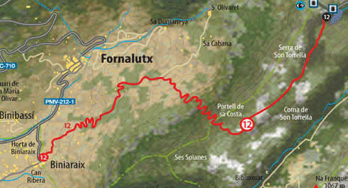
The Narrow pass of Sa Costa or Na Martorella Path is one of the routes used most to access the highlands of Son Torrella, already in the district of Escorca, and the olive groves of the Des Marroigsarea. The first part of the route which, as a whole, is very steep, runs along the old Monnáberroad which is accessible to vehicles, but then we will leave it to make our way up the mountain taking the Na Martorellapath. After getting through the Narrow pass of Sa Costa we enter Son Torrella and, between the very high rocky slopes, we reach the C-710 road. The village of Biniaraix, well signposted from Sóller, is the starting point of this demanding route which leads us to the highlands of Son Torrella. Near its public washing places we take the asphalted path which quickly gains height amongst the olive groves. We take the Monnáber road; and as we ascend, the views over the Fornalutx valley become breathtaking. Once the bends area has been completed, and still amongst the olive groves, we reach the start of the Na Martorellapath. It is easy to find on the right as it is a long, steep cobbled straight path, closed in by two walls which contain an irrigation which in winter channels the overflow of the Na Martorellafountain at whose source we can quench our thirst. We have already reached an altitude of 350 metres, but there still lies before us the steepest slope until reaching the 900 metres of the Narrow pass of Sa Costa. |
After passing a cart track, we go on our way between sheds, olive trees and strips of land until entering Garriga. From here onwards the state of the path worsens considerably and we have to take care with our route. Suddenly we start gaining height, leaving behind us stone slopes, pines and holm oaks, thus arriving at the Narrow pass of Sa Costa via which we can access the district of Escorca. This point constitutes an exceptional vantage point over the districts of Sóller, Fornalutx and part of that of Escorca; what's more, the view over the coast more than justifies its name. On the right we can behold the Gully of Biniaraix and the stone slope of Es Verger. After a break after the steep ascent of over 800 metres, on our left we go down to the valley of Son Torrella, slotting in between the mountain range of the same name and that of Cúber, and by way of a copse of holm oaks we reach the C-710 road, near the southern mouth of the tunnel (km 36.8) and nearby Es Noguer and at the feet of Puig Major. |
|
||||||||||||
|
||||||||||||||
 Download
 See Description of the Route |
||||||
 |
||||||
|
||||
|
||||